Trail Map / Directions
|
Trail Map / Directions |
|
|
|
|
|
|
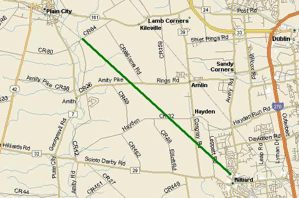
The Heritage Trail shown on the map in green, runs from Old Hilliard to Cemetery Pike Road
|
|
DETAILED MAP OF THE HERITAGE TRAIL
|
|
Distances along the Heritage Rail Trail
|
|
Directions to Plain City From the End of the Trail (and The Der Dutchman Restaurant) At the trail end, make a left onto Cemetery Pike and follow this around a curve to the right. You'll pass a big cemetery and cross the Darby Creek. Turn right onto Plain City-Georgesville Road and follow this into Plain City. The Darby Township Cemetery is on your right and you'll follow the Darby Creek into town. In Plain City, you'll pass the Municipal Building, Water Tower, and Fire Station. Turn left onto Main Street (Rt. 41/161W). Watch for trucks, this is a major intersection. Follow Main through town, past the school and The Eskimo Ice Cream Stand to Jefferson Avenue. Turn left here (at the Speedway Gas Station) and The Der Dutchman Restaurant is a couple hundred yards on the left. If you eat too much, you may be calling for a ride home.
|
| Click to view more information on Adobe Acrobat |